Abhiya Abbas Mundol
Assistant Professor, Civil Engineering

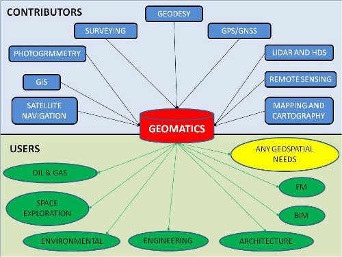
Geomatics is a course offered in the fifth semester B.tech Civil Engineering program under KTU. This course will help the students to possess knowledge on the advanced methods of surveying, the instruments and the spatial representation of data.
CE 207 Surveying
Traverse Survey, Curve Surveying, Global Navigation Satellite System, Global Positioning Systems, Remote Sensing, Geographical Information System
Download detailed syllabus (pdf)

Assistant Professor, Civil Engineering
1. Dr. B.C. Punmia , Ashok Kumar Jain & Arun Kumar Jain - Surveying , Laxmi publications (P) Ltd , 2005
2. Prof. T.P. Kenetkar and Prof. S.V. Kulkarni - Surveying and Levelling, Pune Vidyarthi Griha Prakashan,2004
3. R.Agor - A Text book of Surveying and Levelling, Khanna Publishers, 2005
4. S.K. Duggal - Surveying Vol. II, Tata McGraw Hill Ltd ,Reprint 2015
1. Burrough P , Principles of Geographical Information systems, Oxford University Press, 1998
2. Chang,K , “Introduction to Geographic Information Systems”, Tata McGraw-Hill Publishing Co. Ltd, 2008
3. George Joseph, “Fundamentals of Remote Sensing”, University Press, 2003
4. Iliffe, C.J., Datums and Map Projections for Remote Sensing, GIS and Surveying, Whittles Publishing, 2006
5. James M Andersen, Edward M Mikhail, Surveying Theory and Practice, McGraw Hill education, 7e, 1998
6. Kang-tsung Chang, „Introduction to GIS‟ , Tata McGraw-Hill Publishing Co. Ltd, 8e, 2016
7. Lillesand M and Kiefer W, “Remote Sensing and Image Interpretation”. John Wiley and Sons,Inc., 2000
Fifth Semester B.Tech Civil Engineering Students - 2018 Admission year